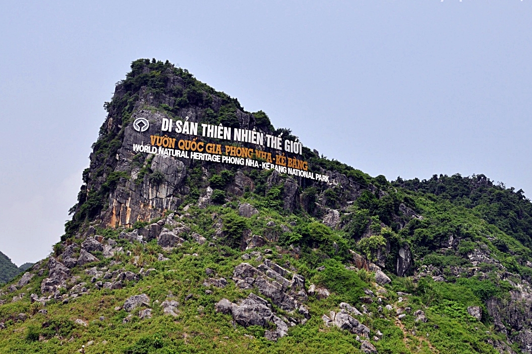
Phong Nha – Ke Bang National Park is a natural beauty that nature has bestowed upon Quang Binh. A land associated with heroic historical feats. Here, the harmony of primeval forests and Son River, together with dry caves and water caves, creates a captivating ink painting. Phong Nha – Ke Bang has been recognized by UNESCO as a world natural heritage twice on July 5, 2003 and 2015.
This is also home to Son Doong Cave, the world’s largest cave, along with hundreds of famous large and small caves such as Phong Nha Cave and Thien Duong Cave.
Phong Nha Ke Bang National Park is named after Phong Nha Cave, the most beautiful cave, known as the number one cave, including majestic rock formations and Ke Bang Mountain.
Geographical location of Phong Nha Ke Bang National Park
Phong Nha – Ke Bang National Park is a national park of Vietnam, located in Bo Trach and Minh Hoa districts, Quang Binh province, about 50 km northwest of Dong Hoi city, about 500 km south of Hanoi capital. This national park borders Hin Namno nature reserve in Khammouan province, Laos to the west; 42 km east of the East Sea from the border of this national park.
Area: 123,326 ha, including 03 sub-zones: strictly protected sub-zone (100,296 ha); ecological restoration sub-zone (19,619 ha); administrative service sub-zone (3,411 ha).
The buffer zone has an area of 219,855.34 hectares in 13 communes (including Dan Hoa, Hoa Son, Trung Hoa, Thuong Hoa, Trong Hoa communes of Minh Hoa district; Tan Trach, Thuong Trach, Xuan Trach, Phuc Trach, Son Trach, Phu Dinh, Hung Trach communes of Bo Trach district and Truong Son commune of Quang Ninh district).
History of Phong Nha Ke Bang National Park
Before becoming a National Park, this was a Nature Reserve with an area of 50km2, established by the Vietnamese government on August 9, 1986. In 1991, the area of the reserve increased by 41,132 hectares.
On December 12, 2001, the Vietnamese Government decided to establish a National Park with an area of 85,754 hectares with 3 main subdivisions:
Administrative service area of 3,411 ha,
Ecological restoration zone, area 17,449 ha
Strictly protected area, area 64,894 ha.
In July 2003, Phong Nha Ke Bang National Park was officially recognized as a World Natural Heritage with two criteria: geology and geomorphology. On July 3, 2015, Phong Nha Bang National Park was honored to be recognized by UNESCO as a World Natural Heritage for the second time with the criteria of biodiversity and ecology.
Weather and climate inPhong Nha Ke Bang National Park
Phong Nha-Ke Bang National Park has a tropical climate, hot and humid. The average annual temperature ranges from 23 to 25 °C, with a maximum temperature of 41 °C in summer and a minimum of 8 °C in winter. The hottest months of the year are from June to August, with an average temperature of 28 °C, and the lowest temperatures fall from December to February, with an average of 18 °C. Annual rainfall ranges from 2,000 mm to 2,500 mm, with 88% of the rainfall occurring between September and December. The average annual humidity is 84%.
Phong Nha weather is beautiful to experience
Cultural significance
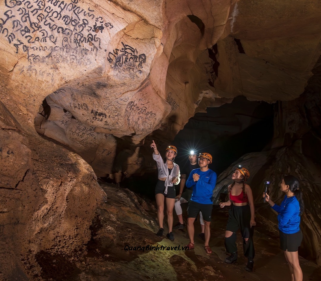
Evidence of human habitation in Phong Nha – Ke Bang has been found in some caves, such as human skulls and man-made objects. In 1899, a French missionary discovered ancient Cham hieroglyphics in Phong Nha cave.
Ancient characters in Phong Nha Cave
After discovering Cham-style ceramics, earthenware jars, stone statues and Buddha statues in Phong Nha cave in 1995, the Vietnam Institute of Archaeology concluded that Bi Ky cave could have been inhabited by Cham people from the 9th to the 11th century (the Champa kingdom existed for 904 years from 192 to 1096).
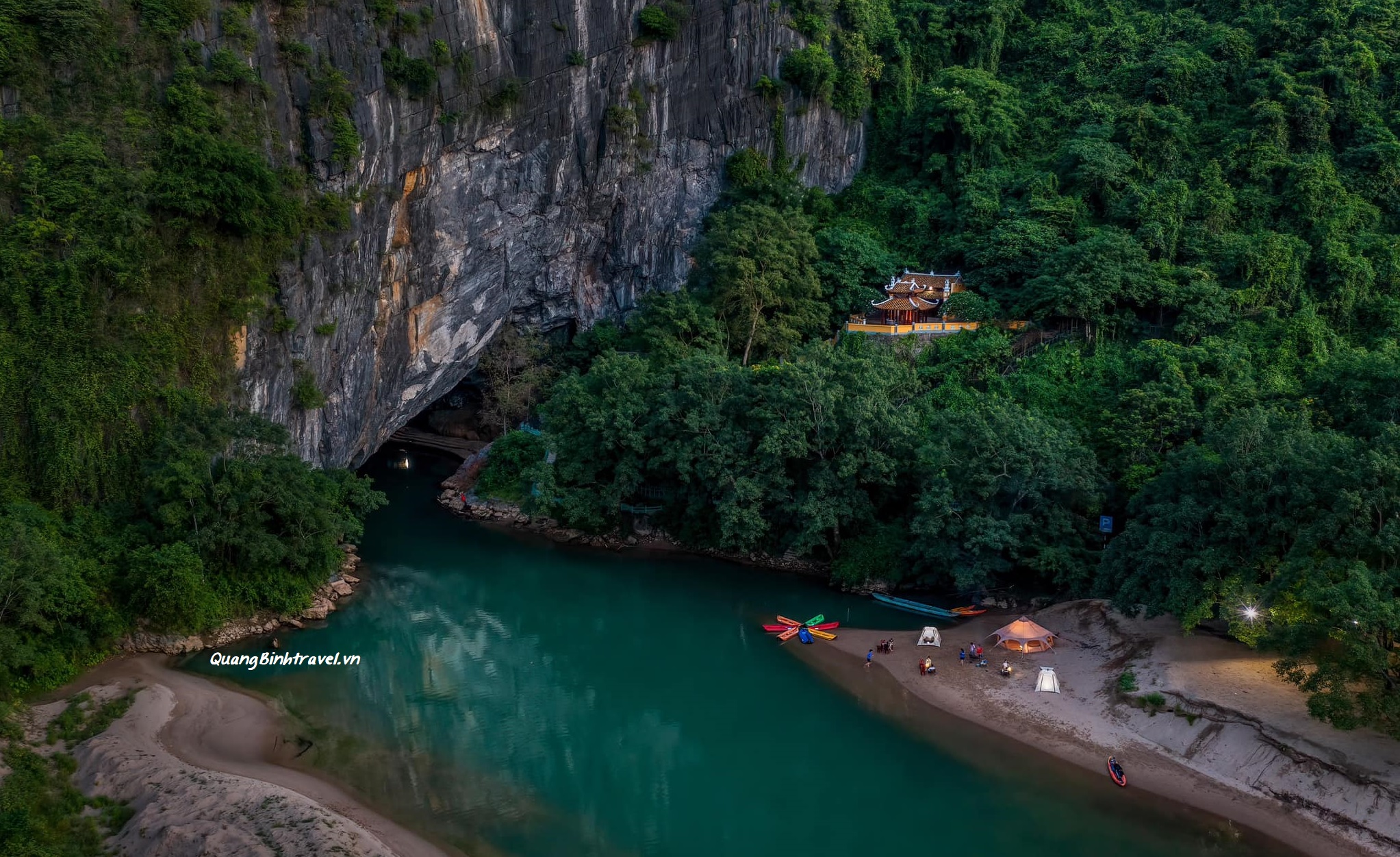
In the early 19th century, a temple was built at the entrance of Phong Nha Cave to worship the Cave God and local people often held an annual festival to pray for rain and good crops.
Temple in Phong Nha cave
Currently, there are about 450 to 500 people living in the core zone of Phong Nha Ke Bang National Park and 50,000 people living in the buffer zone.
The majority of people living in the buffer zone belong to the Van Kieu ethnic minority group (Van Kieu, Tria, Khua, Ma Coong), and the Chut ethnic group (Sach, May, Ruc, Arem, Ma Lieng).
Each ethnic minority has its own cultural characteristics such as hunting, gathering or other traditional activities such as buffalo slaughtering festivals, drum beating festivals, crop praying festivals, and drinking rice wine at festivals.
Historical significance
During the war against the US, many places and caves in the Phong Nha-Ke Bang area were strong bases of the North Vietnamese Army, including Xuan Son ferry, Nguyen Van Troi ferry, Road 20, Tra Ang tunnel, Tam Co cave, and reserve warehouses in caves in Tuyen Hoa and Minh Hoa districts.
Phong Nha Cave was an important place to hide weapons, food, equipment, Bi Ki Cave was used as a field hospital. The entrance to the cave was bombed in 1968 and there are still traces in front of the cave to this day.
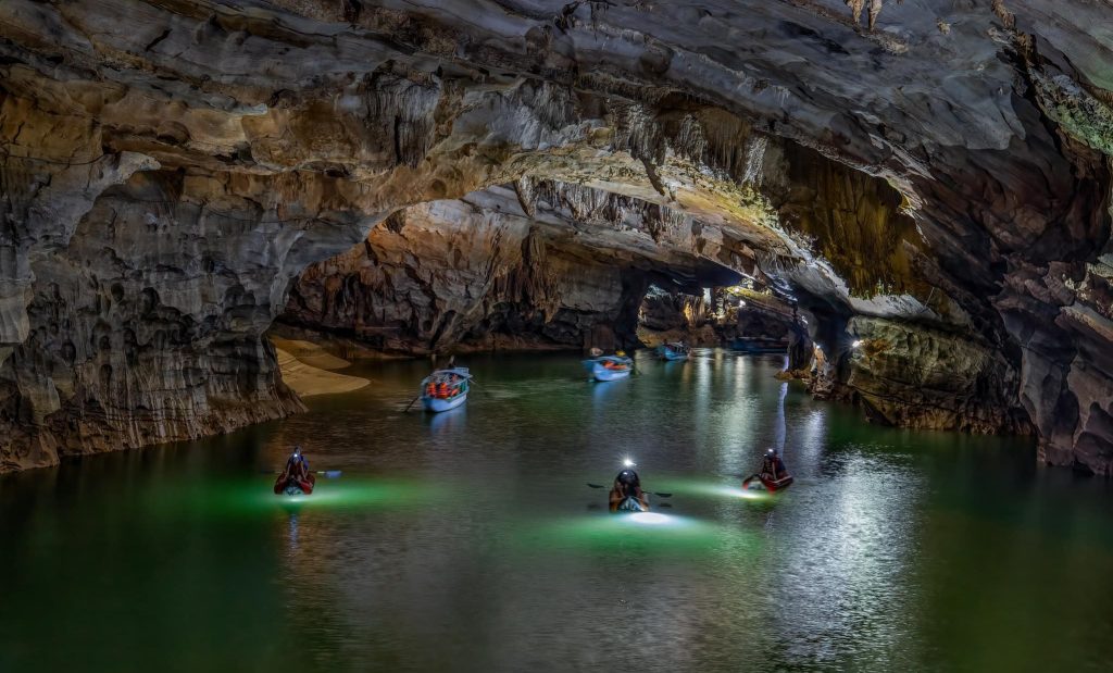
Tourism development in Phong Nha Ke Bang
Tourism in Phong Nha Ke Bang has been exploited since the French colonial period. However, at that time, the services were simple and only served a small number of groups of wealthy guests or high-ranking French military officers. During the war against the US, tourism activities were suspended and were exploited again after the country was unified. The tourism industry in Phong Nha – Ke Bang has been expanded since 1995. Phong Nha Ke Bang National Park is one of the prominent tourist destinations in Vietnam with activities such as cave tours, eco-tourism, local life experience tours – homestay, historical tourism.
Cave Trekking is an attractive activity in Phong Nha Quang Binh
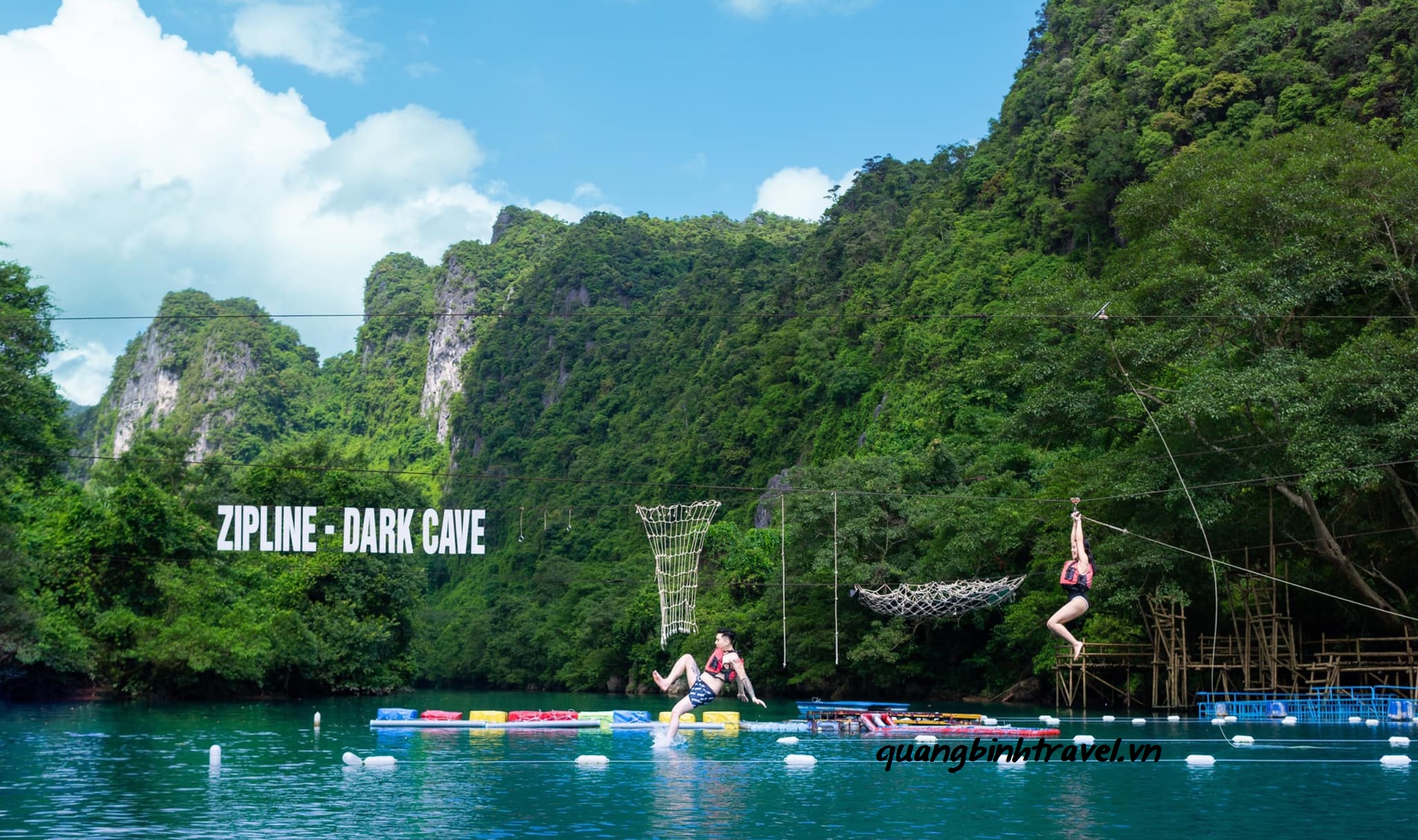
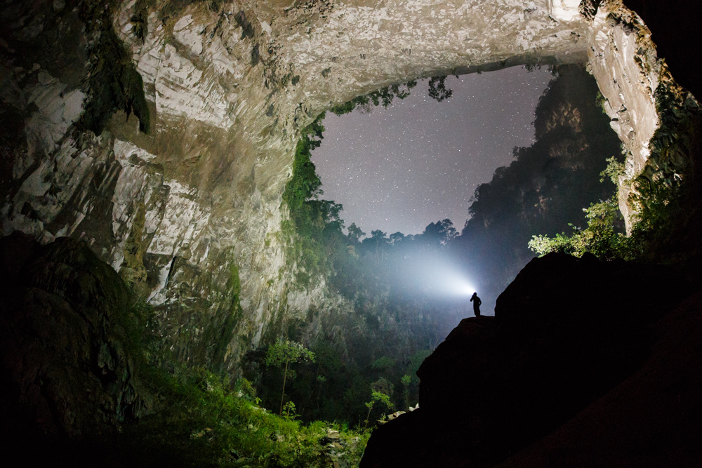
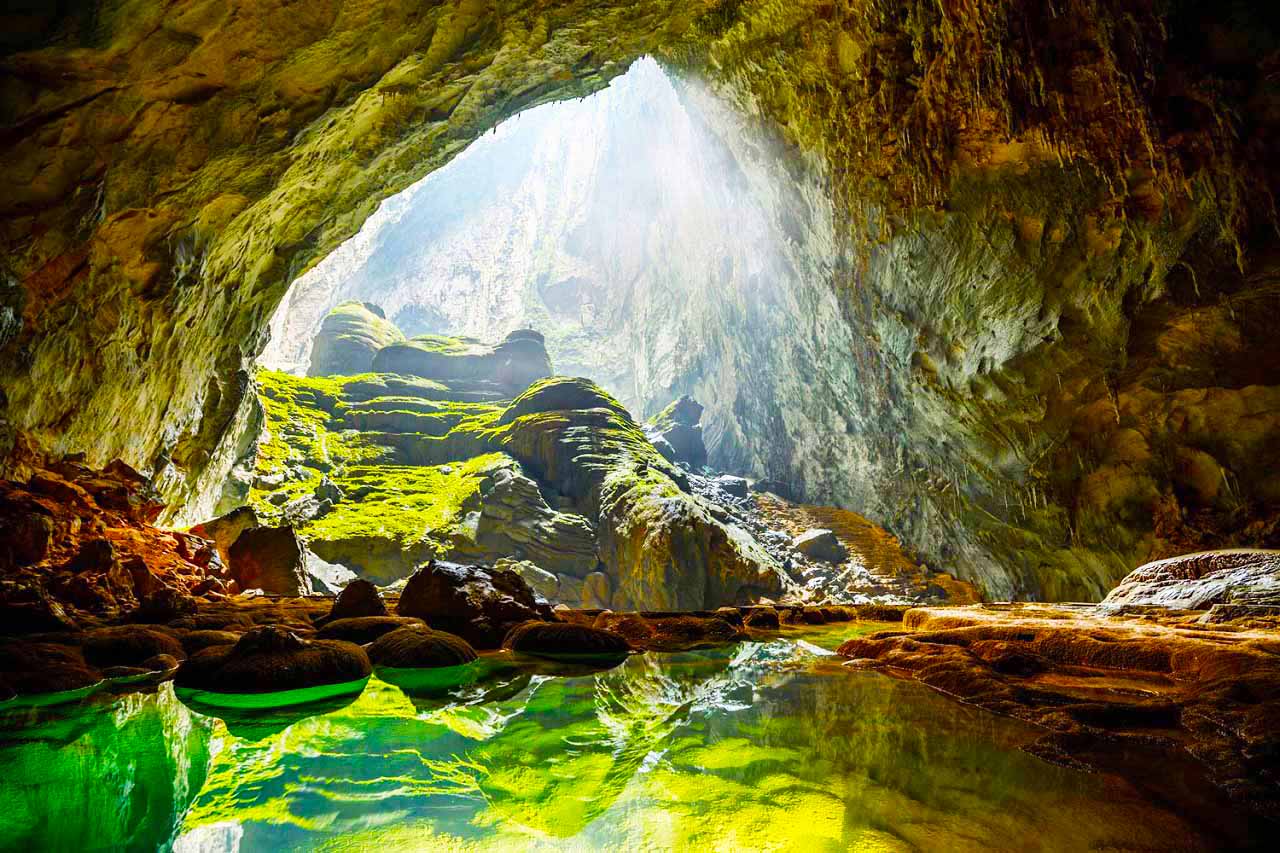
Currently, many Phong Nha Ke Bang tours are opened and exploited for tourists. For example, Son Doong Cave, the largest cave in the world, is exploited for tourism. Many other caves such as Thien Duong Cave, En Cave, or Chay River Dark Cave are exploited for tourism.
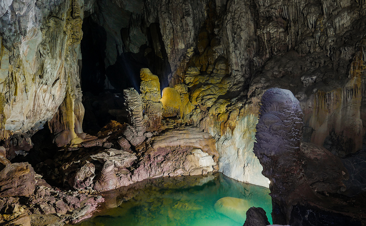
Phong Nha cave
Phong Nha Cave is very convenient for tourists from all over the country to visit because from the North or from the South, you have to go through Bo Trach district. From Dong Hoi city to Hoan Lao intersection, you turn onto provincial road number 2 running in the northwest direction. Continue 16km to reach the Son River bank, you get on a boat to Phong Nha. The waves are rippling, the scenery on both banks is as quiet as a sheet of paper, with a few simple houses of the villagers, a few buffaloes leisurely grazing.
Phong Nha Cave – The first wonder of the cave
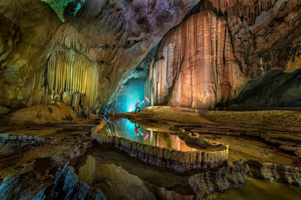
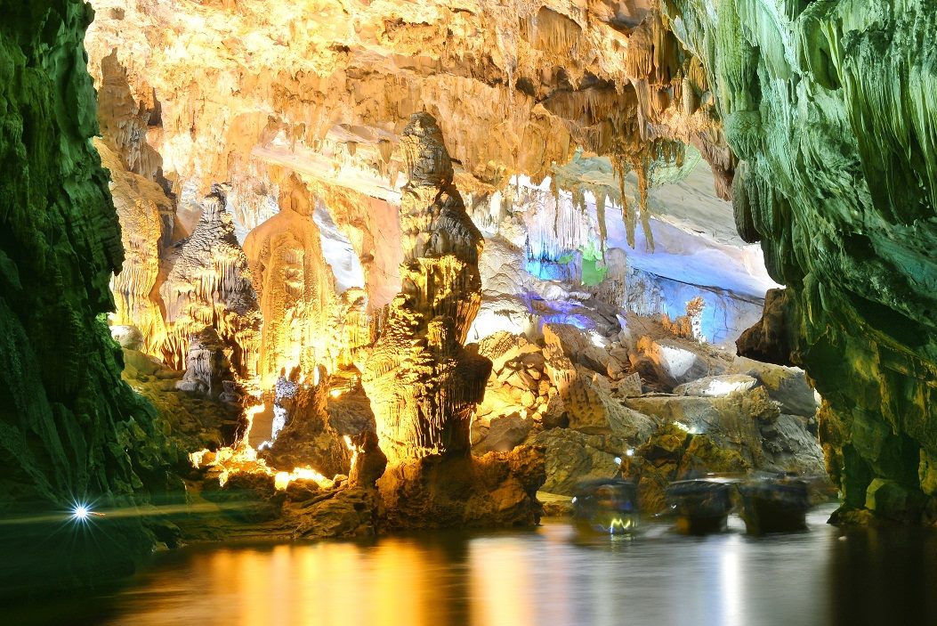
Phong Nha Cave, 7,729 meters long, has 14 caves, with a 13,969 meter long underground river that is the most magical and brilliant. The cave entrance is about 10 meters high and 25 meters wide. From above, stalactites fall down like giant melting dew drops… Phong Nha Cave has two parts: dry cave and water cave. The dry cave is located at an altitude of 200 meters. According to geographers, the underground river has dried up since ancient times, leaving only white stone arches and jade green stone pillars.
The stalactites in Phong Nha Cave have been formed over millions of years from karst limestone, soaked by rainwater, dissolved and flowing down from the cave roof to form extremely strange stalactites such as lions, thrones, Buddha… Rainwater continues to fall to the bottom of the cave, forming calcium to create stalagmites. The rocks, stalagmites, stalactites, underground rivers are of many shapes and sizes, shimmering and majestic. It seems that Phong Nha is the place where all the most perfect beauty of nature converges and where imagination is most sublimated.
In April 1997, a scientific conference on Phong Nha – Xuan Son scenic relic was held in Quang Binh. The survey results showed that Phong Nha has 7 best things:
Longest water cave (Hang Vom – 28km)
The highest and widest cave
The most beautiful wide sandy and rocky beach
The most beautiful underground lake
The most magnificent and magical stalactites
The longest underground river in Vietnam (13,969 m)
The largest and most beautiful dry cave.
The formation and development of Phong Nha – Ke Bang
About 460 million years ago, Phong Nha – Ke Bang was still lying on the seabed. One of the more than 70 minerals dissolved in seawater, calcium, combined with another dissolved mineral, carbon, to form a new mineral called “calcium carbonate” which has a lower solubility than the two original elements. These crystals settled to the seabed and created a black mud layer covering the seabed surface.
Son Doong Cave Images – Ryan Deboodt
Cave development
All limestone is deposited under the sea in layers separated by ‘interfacials’ – the middle where two layers of limestone meet, one above the other. They can be of similar quality but with a weak area between the two layers often created by chemical changes in the water environment in which they form. .
For example, over a million years Calcium carbonate slowly settles to the seabed and 2 meters thick of Calcium carbonate is formed.
A volcano erupts and the volcanic ash flows into the sea and that ash settles to the sea floor and then forms a thin layer on top of the calcium carbonate mud.
Then after another million years, another 2 meters thick of Calcium Carbonate was deposited on top and there was a total of 4 meters of Calcium Carbonate layer.
But in between is a very small layer of many other substances. Eventually, it gets compressed or chemically altered and that layer of sediment disappears, but it leaves behind a weak part between the two layers – called the interface. That layer can be just a few centimeters thick or it can be 10 meters thick depending on how the seawater conditions change while the limestone is being deposited.
Limestone is very brittle and so as it is uplifted or downlifted or moved sideways by the forces that formed our planet, it develops vertical cracks called joints and sometimes the movement creates flat layers separating the layers. Joints and separating layers create passages that allow the rapid movement of water into the easily soluble rock.
Water flows in the limestone and further it dissolves, expanding these passages and changing from small tubes to large corridors about 30 meters in diameter and more – and all covered by the water flowing in it
As the flat land is slowly uplifted by tectonic forces and the limestone is tilted and placed into a period of weathering and further faulting, the cave corridors that have formed are drained and new ones are formed.
The doors of the cave corridors are placed outside the Earth and a cave is formed.
It is not a simple process but it happens over a very long time and there are many other phenomena that are also happening.
Fascinating stalactites in Phong Nha Ke Bang
The development of a cave as it is filled with water produces a range of predictable shapes and features, depending on the particular qualities of the limestone itself, the shapes of the joints and layers, and the quality, quantity and speed of the water flow.
In hard limestone, the characteristic shapes of underwater development are long horizontal planes, tube-shaped galleries with very smooth cave walls formed by fast-flowing water along joints and aligned layering planes.
The flowing water leaves behind it shapes called scallop flowers as it dissolves the limestone.
If the patterns are small then it tells us that the water flow is very fast and the direction of flow can be determined as the patterns are usually deeper at the end of the flow.
The shapes of the joints and layering surfaces can also create winding cave passages that extend up, down or sideways and often feature carved limestone concave and convex shapes that are suspended from the cave ceiling, growing from the cave floor or attached to the cave walls.
During the long period of time it takes for a cave to form, changes in weather, movement of flat lands and river erosion lead to changes in the water table where the cave is being formed.
As the land subsided, the water level rose and the speed of water flowing through the limestone slowed or stopped and strange shapes were formed as the static water randomly eroded the limestone surfaces.
As the land subsided, the water level rose and the speed of water flowing through the limestone slowed or stopped and strange shapes were formed as the static water randomly eroded the limestone surfaces.
When the cave is covered with water up to the ceiling, part of the ceiling is supported by water, but when the water recedes, that support is lost and the wide cave corridors collapse to the cave floor, destroying the original shape of the cave.
Part of cave development is called ceiling collapse, where the flat ceiling of a cave is the weakest part of the cave. If the cave ceiling is flat and wide, the central part of that ceiling – a layer of limestone – will fall into the cave and settle into the bottom of the next layer.
In areas with high rainfall, water can continue to flow and dissolve collapsed rock to form large cave chambers connected by keyhole-shaped cave galleries where the flowing river dissolves limestone only from the cave floor and lower walls of the cave galleries.
Layer after layer collapses if the layers are too thin to support themselves, until the cave takes on a dome shape. Or the top layer of limestone falls down creating a collapsing basin.
Sinkholes in Son Doong Cave
The quality of the limestone, the thickness of the layers, and the tilt during uplift all add to the variety of sizes and shapes of limestone caves.
Many other marine organisms also take calcium and carbon from the seawater to form strong protective shells, and when these organisms die, their shells also settle to the seabed.
The black mud gets thicker and heavier, clumped together with calcium carbonate crystals and shells. This sedimentary rock is called limestone.
Between 460 and 50 million years ago, the powerful tectonic movements that formed the earth’s crust pushed the sedimentary layers of Phong Nha Ke Bang through a process of uplift, downfall, and finally rising above the seabed. This is a complex process that humans do not yet fully understand, but we are certain that about 50 million years ago, this area was lifted above the seabed, heavy rains seeped into and eroded the limestone mountains, creating the majestic beauty and mysterious cave system of Phong Nha – Ke Bang National Park today.
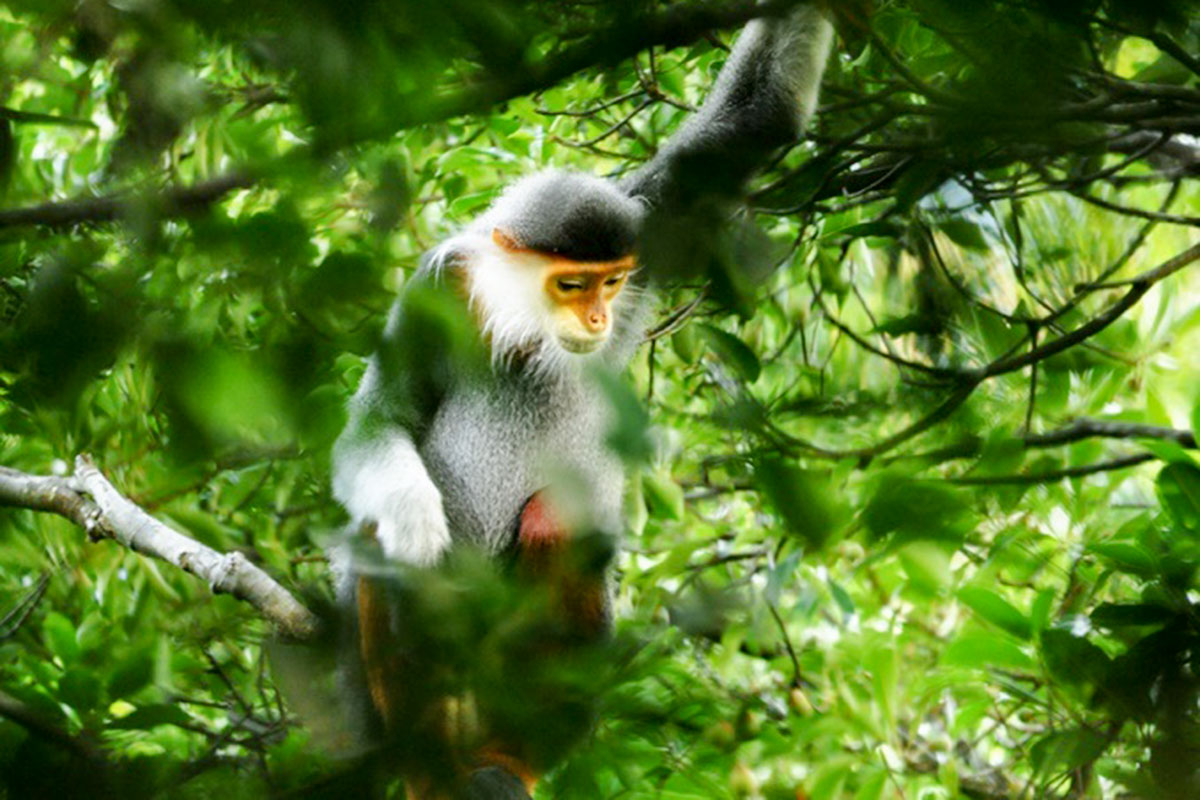
Biodiversity
Biology refers to living organisms and diversity means many species, hence the term Biodiversity means many living organisms.
Phong Nha Ke Bang with many rare flora and fauna
All living organisms depend on their environment, which consists of living and non-living elements. The combination of these living and non-living elements forms a biome.
There are aquatic biomes (marine and freshwater organisms) and terrestrial biomes (deserts, forests, grasslands), each biome has many different ecosystems, the organisms in the ecosystem adapt to each change in climate and environment in the biome.
Ke Bang forest biome
In the forest biome, there are many types of forests.
Temperate forests grow on fertile soil, mild climate with different seasons (spring, summer). Average rainfall is about 75 to 150 cm/year. Flora includes 3-4 species/km2
Taiga forests, commonly found at about 50 and 60 degrees north latitude, where the seasons are long, cold, dry winters and short, wet summers. The soil is thin, low in nutrients, and there is little precipitation (mostly snow), with annual precipitation ranging from 40 to 100 cm.
The rainforest is not one ecosystem, but millions of ecosystems together. It is the central system, the lifeblood of the world, civilizations, life, diversity. Above all, the rainforest is the world’s most beautiful gallery.
Tropical rainforests are typically found in areas where rainfall is greater than 200 cm and rains year-round.
Temperate rainforests occur between about 23 and 50 degrees from the equator, where there are distinct seasons.
Tropical rainforests are found only in areas more than 23 degrees from the equator, with the same 12 hours of day and 12 hours of night all year round. The average daytime temperature is about 20-25 degrees, all year round.
Visit Phong Nha Ke Bang
Phong Nha is unlike other tourist destinations in Vietnam, the cave is located in the Ke Bang primeval forest, which seems to be pristine and pure. In the eyes of tourists, the local residents here have a very unique style “They behave friendly and affectionately like pure farmers rather than seeing tourists as an opportunity to find financial resources. This makes Phong Nha even more attractive to tourists”.
Phương tiện di chuyển từ Hà Nội đến Quảng Bình rất thuận tiện khi có nhiều phương án để lựa chọn như máy bay, tàu hỏa và đường bộ. Theo thống kê thì Quảng Bình là tỉnh có nhiều du khách từ Hà Nội đến du lịch nhất. Quảng Bình là địa phương vừa có […]
From 1st to 10th of March, Netin Travel had the honor of welcoming Mr. Tijmen, a representative from the PUM Organization. His visit was part of a short-term training program aimed at enhancing the quality of tourism services and experiences offered by Netin Travel. In this time, Mr. Tijmen fully immersed himself in the vibrant local lifestyle of Dong Hoi City and Phong Nha Town. […]
Phong Nha Cave is a cave in the limestone mountains of Phong Nha – Ke Bang National Park. Known as an attractive and famous destination of Quang Binh Tourism, the cave has been put into tourism operation since 1991. After going upstream Son River, tourists will visit Phong Nha Cave with a magnificent system of stalactites with 7 outstanding […]
Quang Binh is famous for many famous tourist areas not only domestically but also internationally. Among them, Suoi Da Quang Binh is considered a unique eco-tourism area that attracts many visitors because of the majestic and poetic beauty of the mountains and forests. Suoi Da is a new destination of Quang Binh Tourism. Let’s explore […]


