Among the cross-roads of the Ho Chi Minh Routerelic system in Quang Binh, Route 16 is the route that appeared quite early and has special significance as the shortest route to the 17th parallel and is the twinned route of the three provinces of Binh – Tri – Thien.
Route 16 is one of the four crossroads of the Ho Chi Minh Trail system in Quang Binh, starting from Thach Ban intersection (Phu Thuy – Le Thuy) to the North of Xe – Bang – Hieng River, 84 km long. In 1959, after the supply for the people of Tri – Thien and the South who were terrorized by the US – Diem government. The Ministry of Transport realized that this was a short and secret route, which could be used for long-term service for the resistance war, so it decided to expand and upgrade it gradually in 1960, 1965, and 1969.
Route 16, also known as Thong Nhat Road, is the road that carries the aspirations, will and determination of all forces that participated in fighting and working on the road. In the early period until 1965, Route 16 was mainly used for porters, because during this time we had to open and upgrade the road while keeping the road close to the border a secret. Later, when it was gradually expanded, Route 16 was used for motor vehicles.
Along the length of dozens of kilometers winding through the Truong Son mountains and forests, crossing many high passes and deep ravines, it can be said that there is no place on Route 16 that does not have relics marking the plowing by American bombs and bullets, especially in the years from 1970-1971: “In the dry season of 1965-1966, the enemy attacked Route 12 87 times, Route 20 102 times. In the dry season of 1970-1971, the enemy attacked Route 12 617 times, Route 20 926 times, Route 10 579 times and Route 16 1,114 times”. However, the American bombs and bullets could not intimidate the spirit of our army and people, on the contrary, they increased hatred and determination to fight against the destructive actions of American imperialism.
The more fiercely the enemy bombarded, the more goods were brought into the South. In 1971 alone, the volume of transport on Highways 16 and 18 increased 1.7 times in February, 2.1 times in March, and 3.3 times in April compared to January.
Route 16 welcomes many leaders and politicians
During the fiercest years of war, Highway 16 was also honored to welcome many leaders of our Party and State, such as General Vo Nguyen Giap – Politburo member – Minister of National Defense and many comrades such as Comrade Tran Nam Trung (Tran Luong) – Secretary of Inter-Zone V; Comrade Tran Van Tra – Deputy Chief of the General Staff of the Vietnam People’s Army; and many other Party and State leaders who came to inspect the road opening as well as visit and encourage cadres, soldiers and combat and labor forces on the road.
In 1973, Route 16 was also honored to welcome Cambodian Head of State Norodom Sihanouk and Queen Movich back to visit the country after many years living abroad. Through Route 16, the Cambodian Head of State expressed his admiration for the brave spirit of determination to fight and win of the Vietnamese army and people and he was also deeply moved by the help of our Army. On this occasion, he also presented the Truong Son Command with the poem “Grateful for the Ho Chi Minh Trail” with verses filled with warm feelings between the two countries.
Route 16 has 3 important relic sites: Thach Ban Crossroads, Bang Mineral Spring, and Ho Village.
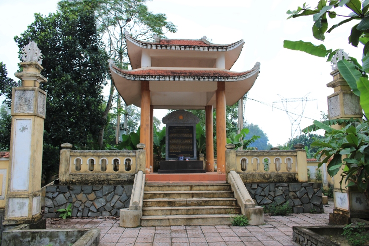
Thach Ban crossroads relic site:
Thach Ban crossroads is the starting point of Highway 16, also known as Thong Nhat route, the name of the road represents the aspirations, will and determination of the army and people of the whole country. Thach Ban crossroads is also the starting point of the Thach Ban – Khe Ho (Vinh Linh) route, one of the first routes of Group 559, with an extremely important position connecting the rear with the front line, of which Quang Binh is the bridge.
Thach Ban crossroads
During the years from 1968 to 1973, Thach Ban crossroads was the station of Ban B – a base to welcome cadres and people from the two provinces of Tri – Thien to study, work, rest and recuperate. The establishment of Ban B at Thach Ban crossroads demonstrated the spirit of solidarity and attachment between the people of Quang Binh and the people of Tri – Thien during the most fierce war years. Thach Ban crossroads was also the location of the Truong Son Command Headquarters in 1973 and the stationing place of the 13th Transport Automobile Regiment – Group 559. From 1965 to 1973, the US Air Force focused on extremely fierce attacks on Thach Ban crossroads. At this key point, the resistance forces, soldiers, youth volunteers, frontline workers and local people worked day and night, fought bravely and resiliently to open the road, clear the route, and ensure timely support for the southern battlefield.
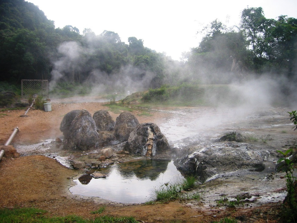
About 10km west of Thach Ban crossroads on Highway 16 is the historical site – Bang mineral spring. This area has a spacious but quite private terrain, with a natural hot mineral spring. During the resistance war against the French colonialists, this area was the Le Thuy district’s war zone. During the years of fighting against the Americans, Group 559 chose this place as the military medical unit’s base. The unit’s communal hospital has up to 50 beds, managed by Dr. Pham Van Phoi (the earliest doctor to join the front line).
Bang mineral spring
Together with the 2 infirmaries of Regiment 70, Regiment 71 coordinated to form a treatment ladder, improving the effectiveness of treatment for wounded soldiers on the entire front. In 1973, continuing to promote the advantages of this area, Comrade Dong Sy Nguyen – Commander of Group 559 built a Nursing Station along with blocking streams and building bathing pools to serve Truong Son troops and wounded soldiers transferred from the battlefields.
Since 1991, Le Thuy Mineral Water Exploitation Enterprise under the Quang Binh Department of Industry has begun to exploit mineral water sources. Through research projects, it has been concluded that Bang spring mineral water contains many rare trace elements that are very good for health, and is favored by consumers everywhere. In addition, with the advantage of being the hottest mineral spring in Vietnam, with hot and cold soaking pools, and located among beautiful pine hills and primeval forests, Bang spring area is an ideal place to build an eco-tourism model in Quang Binh.
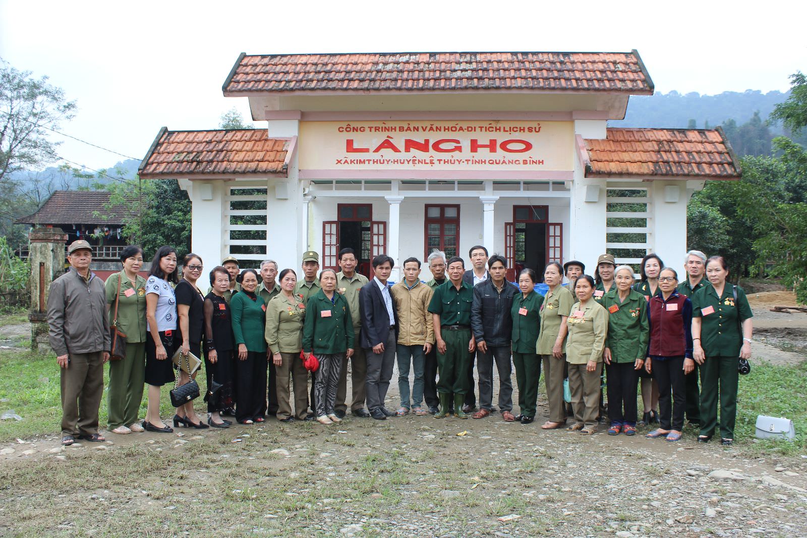
Ho Village relic site
The Ho village relic site is located on Route 16, in Kim Thuy commune. At the end of 1959, Ho village was chosen by Group 559 to be the forward command post. Ho village was the starting point of the “Go without traces, cook without smoke, speak without sound” backpacking campaign, an effective support route for the Tri – Thien battlefield and Zone V from 1959 – 1962. In the years 1966 – 1967, the army and youth volunteers focused on the campaign to simultaneously open and upgrade the road from Thach Ban to Ho village, Ho village – Khe Sanh, Ho village – Ban Dong. Thanks to careful preparation, we launched a general attack and successfully ended the Mau Than campaign in 1968 and the Route 9 – Southern Laos campaign in 1971.
Ho Village Historical Site
During the first time of stationing, Group 559 had to face many difficulties and shortages. However, thanks to the enthusiastic help of the ethnic people here, Group 559 gradually built a rear base from the Command Center, warehouse, infirmary, production camp, reception station… Goods from the North were gathered here and then transported via Highway 16 to the battlefields of the South and Tri Thien. With a terrain of many mountains, hills, streams, caves, Ho village has become the safest place to gather goods.
During the first time of stationing, Group 559 had to face many difficulties and shortages. However, thanks to the enthusiastic help of the ethnic people here, Group 559 gradually built a rear base from the Command Center, warehouse, infirmary, production camp, reception station… Goods from the North were gathered here and then transported via Highway 16 to the battlefields of the South and Tri Thien. With a terrain of many mountains, hills, streams, caves, Ho village has become the safest place to gather goods.
Route 16, along with other routes in the Ho Chi Minh Trail system, transported more than 1.5 million tons of goods; 45 million tons of weapons and 5.5 million cubic meters of gasoline to the battlefield, along with more than 2 million cadres and soldiers marching to the South, contributing to the final victory of the resistance war against the invading American imperialists: completely liberating the South and reunifying the country.
Phương tiện di chuyển từ Hà Nội đến Quảng Bình rất thuận tiện khi có nhiều phương án để lựa chọn như máy bay, tàu hỏa và đường bộ. Theo thống kê thì Quảng Bình là tỉnh có nhiều du khách từ Hà Nội đến du lịch nhất. Quảng Bình là địa phương vừa có […]
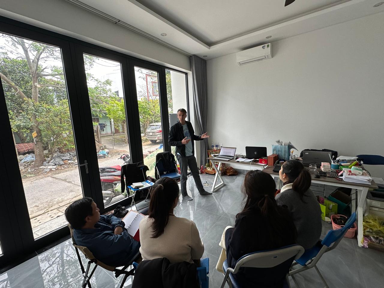
From 1st to 10th of March, Netin Travel had the honor of welcoming Mr. Tijmen, a representative from the PUM Organization. His visit was part of a short-term training program aimed at enhancing the quality of tourism services and experiences offered by Netin Travel. In this time, Mr. Tijmen fully immersed himself in the vibrant local lifestyle of Dong Hoi City and Phong Nha Town. […]
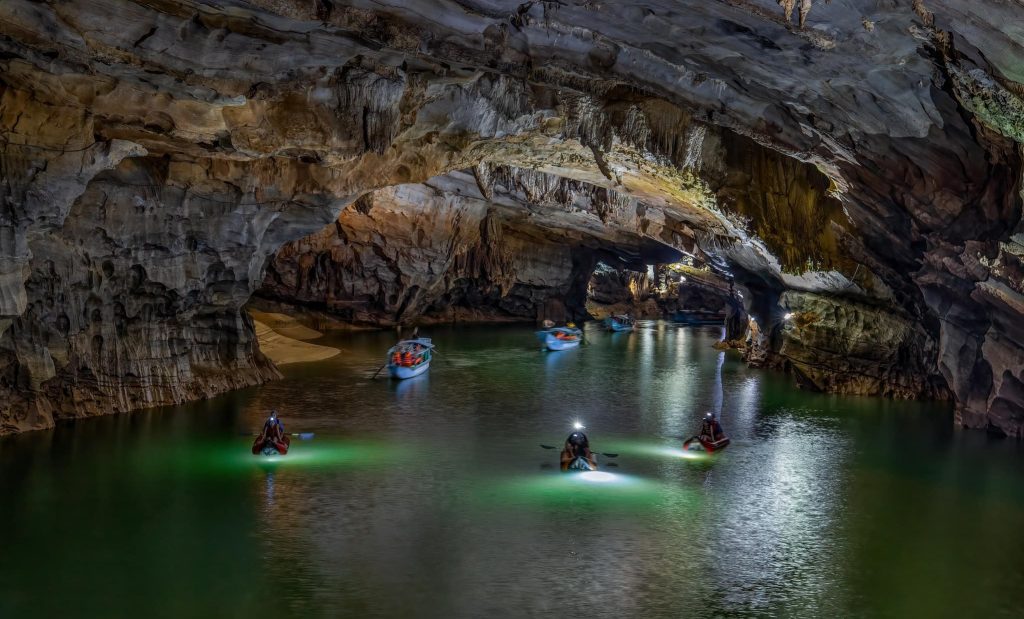
Phong Nha Cave is a cave in the limestone mountains of Phong Nha – Ke Bang National Park. Known as an attractive and famous destination of Quang Binh Tourism, the cave has been put into tourism operation since 1991. After going upstream Son River, tourists will visit Phong Nha Cave with a magnificent system of stalactites with 7 outstanding […]
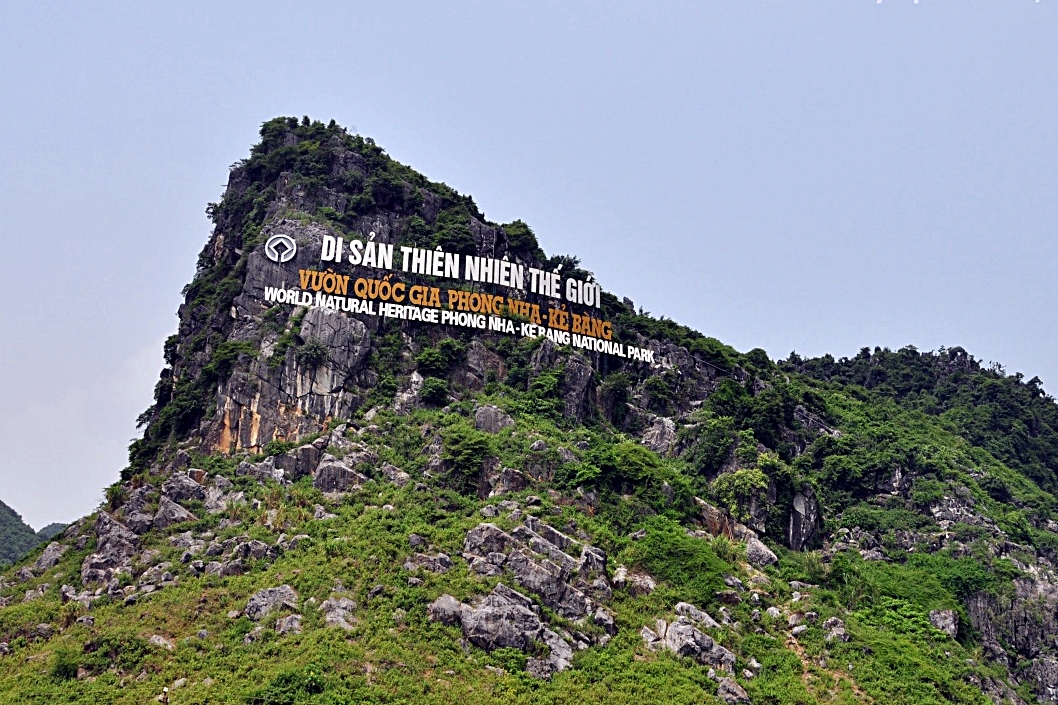
Phong Nha – Ke Bang National Park is a natural beauty that nature has bestowed upon Quang Binh. A land associated with heroic historical feats. Here, the harmony of primeval forests and Son River, together with dry caves and water caves, creates a captivating ink painting. Phong Nha – Ke Bang has been recognized by […]
Phương tiện di chuyển từ Hà Nội đến Quảng Bình rất thuận tiện khi có nhiều phương án để lựa chọn như máy bay, tàu hỏa và đường bộ. Theo thống kê thì Quảng Bình là tỉnh có nhiều du khách từ Hà Nội đến du lịch nhất. Quảng Bình là địa phương vừa có […]
From 1st to 10th of March, Netin Travel had the honor of welcoming Mr. Tijmen, a representative from the PUM Organization. His visit was part of a short-term training program aimed at enhancing the quality of tourism services and experiences offered by Netin Travel. In this time, Mr. Tijmen fully immersed himself in the vibrant local lifestyle of Dong Hoi City and Phong Nha Town. […]
Phong Nha Cave is a cave in the limestone mountains of Phong Nha – Ke Bang National Park. Known as an attractive and famous destination of Quang Binh Tourism, the cave has been put into tourism operation since 1991. After going upstream Son River, tourists will visit Phong Nha Cave with a magnificent system of stalactites with 7 outstanding […]
Phong Nha – Ke Bang National Park is a natural beauty that nature has bestowed upon Quang Binh. A land associated with heroic historical feats. Here, the harmony of primeval forests and Son River, together with dry caves and water caves, creates a captivating ink painting. Phong Nha – Ke Bang has been recognized by […]